By David DuByne, December 16, 2012
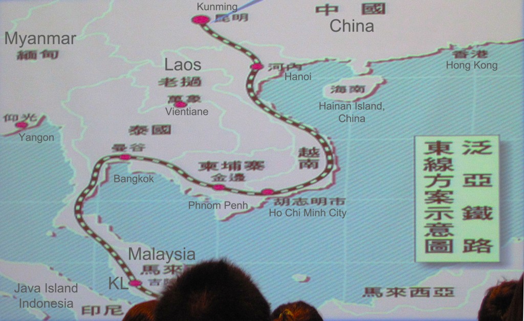
On Friday December 7, the Taiwan External Trade Development Council (TAITRA) hosted a regional China Cross Border Trade and Market Opportunities Conference. My focus was on the border crossing at Ruili in western Yunnan Province connecting through to Lashio and Shwebo in Myanmar. In the same slides I am about to show you below, I learned much more about China’s ambitious overland routes by rail and road throughout S.E. Asia with connections to the Indian sub-continent.
Iron Fangs
Referred to as “The Iron Fangs”, this vastly upgraded rail and road network will encircle all countries touching China’s southern border, with a center pivot point through Kunming. When construction is complete in 2015, roads will tie in deep sea ports throughout Myanmar, interlink Imphal in India’s N.E. Manipur State, plus crisscross all of S.E. Asia’s capitals.
In the 21st century, a new phrase will be coined; “All roads lead to Kunming”, forget Rome!
S.E Asia Routes from China, connecting regional capitals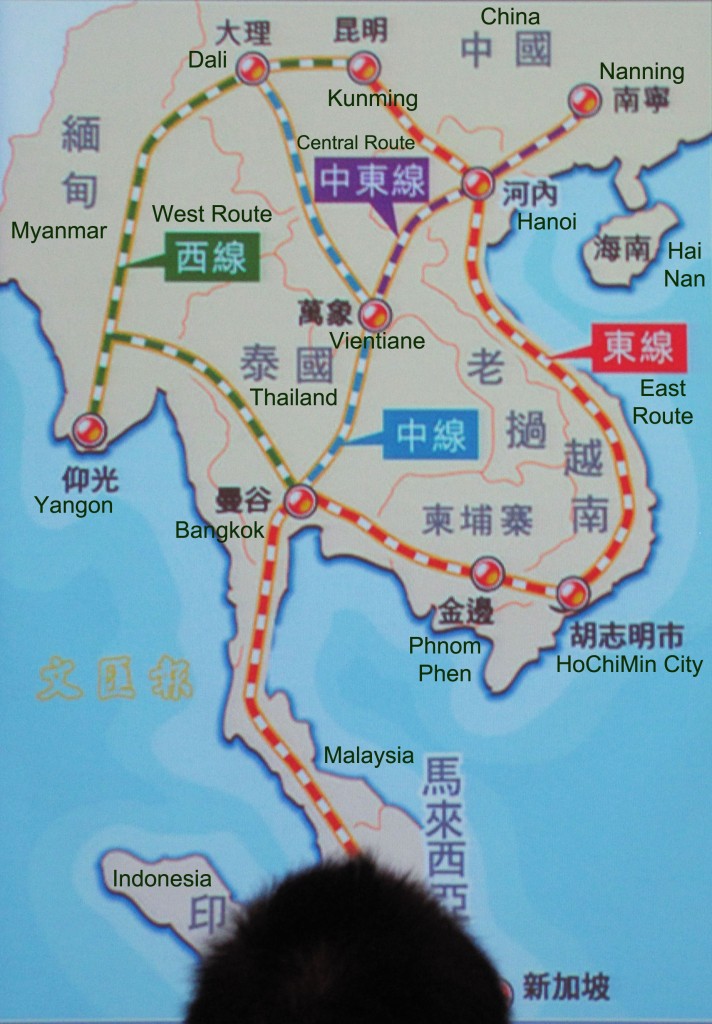
A Far-Ranging View
A wider angle allows you to see the importance of Myanmar’s location more clearly. Take note that the planned amount of cargo flowing through Myanmar to India and the Middle East will rival that from Beijing and Tianjin which forwards goods to the US, Canada and Japan. *(English map translation by Editor Oilseedcrops.org)
A wide angle view of the planned cargo volume: Myanmar -- Kunming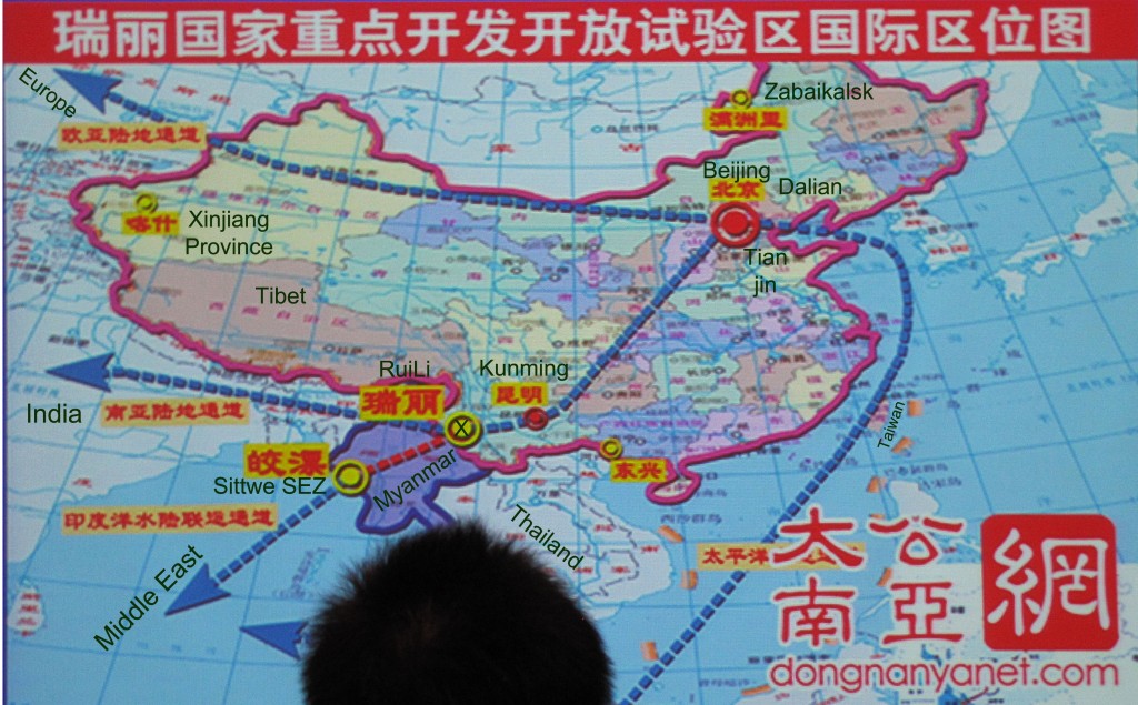
Tianjin Port handled 453 million tonnes of cargo and 11.5 million TEU of containers in 2011, making it the world's fourth largest port by throughput tonnage, and the eleventh in container throughput.*(English map translation by Editor Oilseedcrops.org)
Tianjin, Beijing and Tangshan, cargo from N.E China onward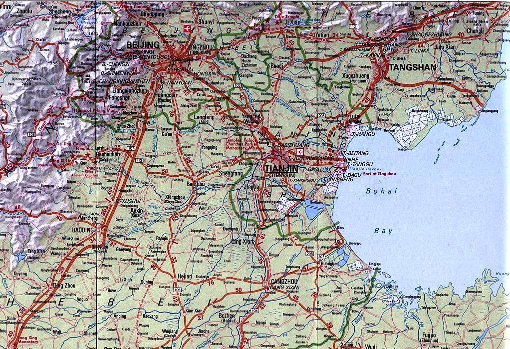
The port trades with more than 600 ports in 180 countries and territories around the world. It is served by over 115 regular container lines run by 60 liner companies. Capacity is still increasing at a high rate, with 550–600 Mt of throughput capacity expected by 2015.
The expectation is that the Special Economic Zone (SEZ) ports at Sittwe and Kyaukpyu in Rakhine State, Myanmar will clear all goods produced in Chongqing, Chengdu and Yunnan Provinces in western China.
The changes are enormous, instead of shipping south out of Chongqing to Shanghai, middle river cities can ship up to Chongqing then deliver through Myanmar by rail or road.
Southern Silk Road Control
China’s blueprint includes complete control over the Southern Silk Road and all freight forwarding within S.E. Asia. Zhongguo's prize is the add-on of total area in the Indian subcontinent that will be accessible by new infrastructure and transit lines. A few overland road and rail lines will connect this area to China’s export market. Reduced shipping costs by at least $900 USD per container will make China made goods even more competitive in India, Bangladesh, Bhutan and Nepal.
Market expansion to the sub-continent region, courtesy of Myanmar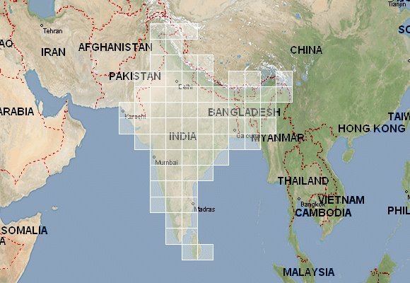
Roads through to Imphal in India’s N.E. States offer direct overland connections to India. This area has long sought independence from India. Impoverished, isolated and underdeveloped, this will also change the significance of what was once a backwater in India to a mega Inter-Asia freight forwarding transit center.
Kunming to India's N.E States through Kalemyo, Saigang, Myanmar
The N.E. States have accused New Delhi of ignoring the issues concerning them and there is a feeling of second-class citizenship meted out to them by mainland Indians. This has led the peoples of these states to seek greater participation in self-governance resource usage, infrastructure improvements and hydro-electric dam building regulation.
Kunming-Mumbai or Kunming-Kabul by rail
Only this little section of road needs to be completed for China to achieve its goal, the re-establishment of the Southern Silk Road. In West Bengal the Siliguri Corridor connects India onward to Eurasia nut the connection at Imphal is essential.
Trans Asia Railway Network, U.N Master Logistics Plan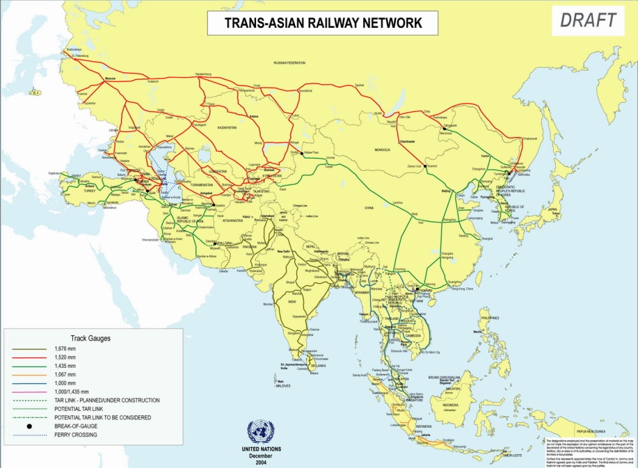
What was the Southern Silk Road?
During the Han Dynasty’s reign of Emperor Wudi (141BC–87BC) the Southern Silk Road was mainly composed of West Route (Maoniu Route) and East Route (Wuchi Route). The West Route originated from Chengdu, wandered through Sichuan Province via Ya'an City, Maoniu (Hanyuan), Qiongdu (Xichang), and took traders to Myanmar (Burma) by way of Dali, Baoshan and Tengchong.
Then its ancient trade route extended through to Juandu (India), Bangladesh and even the Middle East. The East Route was very narrow and had only five-feet wide, so it was also called 'Wuchi Route'. It began from Chengdu, passed through Yibin, Zhaotong, Qujing and reached Kunming, where one branched road went to Vietnam and the other one wound to Dali, joining the West Route. Now the roads are being widened to pass through Ruili.
China’s Vision
The middle man for all freight throughout Asia, with the central hub being Kunming.
China's proposed connections by road, rail and air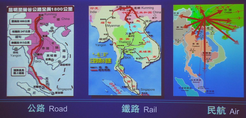
As you see in the maps above; there will be East, West and Central overland routes out of China, connecting through to the remainder of S.E. Asia’s largest cities, all the way south to Singapore. *(English map translation by Editor Oilseedcrops.org)
The East Line will originate in Nanning, Guangxi Province on the Vietnamese border and connect through Bangkok, Kuala Lampur and Singapore.*(English map translation by Editor Oilseedcrops.org)
The Pure Gold Triangle: Kunming-Hanoi-Naning 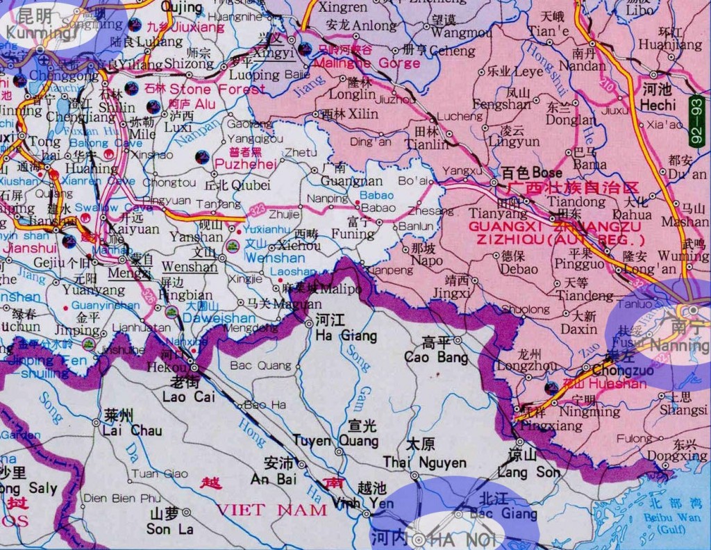
Nanning to Hanoi or a spur line from Kunming to Hanoi, this will funnel transit through Chinese hands. To get to Myanmar’s ports and avoid the Malacca Straights you need to pass through Kunming. Landing ports in Vietnam or China, your choice.
Guanxi Province border with Vietnam; Ports available in QinZhou and FangChengGang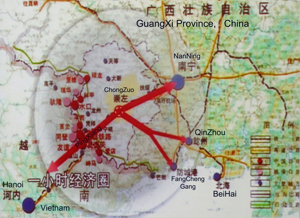
From the Chinese border at Pingxiang porters can legally run 8000RMB of goods across the border by foot. They are termed “Ant Couriers”. This method of customs clearance and reloading a vehicle saves time. Walk 50 couriers over the border, reload onto a Vietnamese registered vehicle, and you are off in a fraction of the time than clearing a fully loaded truck from China into Vietnam. *(English map translation by Editor Oilseedcrops.org)
The Participants
Add some color to your day; these are the participants in the construction scheme.
Infrastructure: Lack or Opportunity
Like all countries in the earliest stages of development, take Myanmar and Laos for example, they have very limited infrastructure. Now think back to America in 1849 or China in 1985. This is the same in terms of development. I believe the rate of construction will surpass the speed of China exponentially. What took China 35 years to do, Myanmar will do in eight.
China Myanmar Rail Connection Network Map.jpg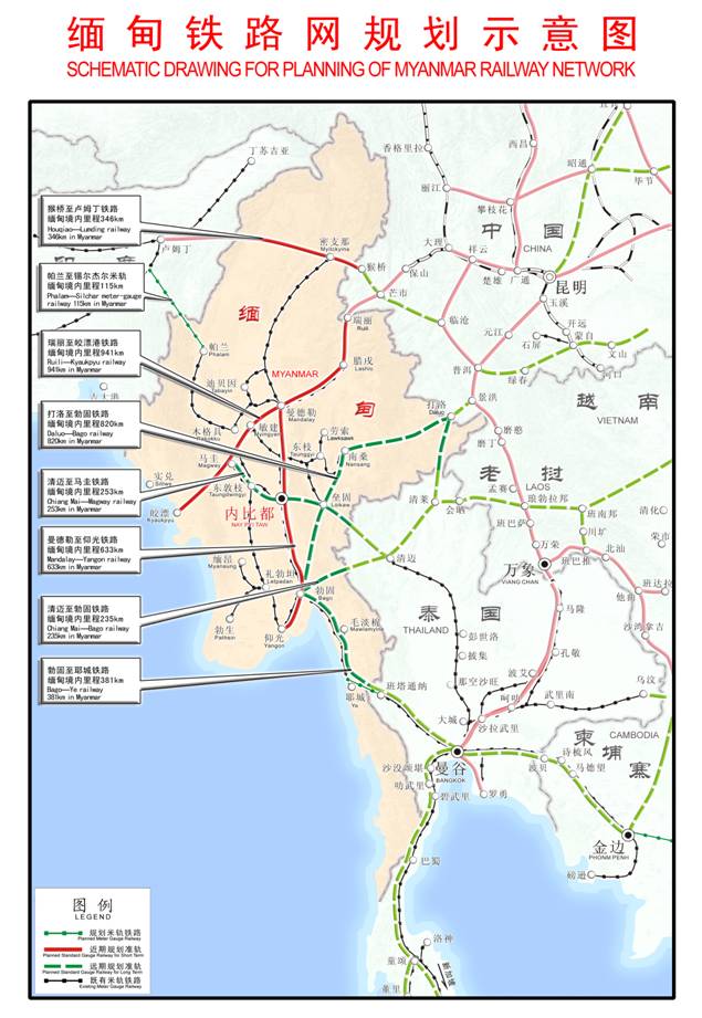
Electricity is in short supply even in Yangon, most power in Myanmar is hydroelectric, and since there are dramatic differences in precipitation in different seasons, electricity supply is correspondingly unreliable. Monsoon season you have 24 hour power, but during the dry season you may get 4-6 hours of power per day. I was in Kathmandu, Nepal in 2010 and they had the exact set of similar circumstances with hydro-power and low water electrical generation problems. Kathmandu languishes in the dark 18 hours per day when there is no rain in autumn.
Oil and Natural Gas Pipelines Route Map Myanmar to China.jpg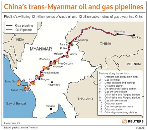
Question:
Where does your firm, company or agency fit in here?
What product, service or parts do you offer to assist in the retro-fit of the country?
David DuByne is the Editor of Oilseedcrops.org and is also a media partner with Advantique Group who is the organizer of the Myanmar Private Sector Investment Summit (MPSIS) Jan 28-30, 2013 in Yangon, Myanmar.
If you thought this article was informative, then you may enjoy another related article David DuByne wrote (Myanmar: Southeast Asia's “Last Frontier” for Investment) published by the Taipei American Chamber of Commerce Topics Magazine November, 2012.


